Most often, a climb to the top of Mt Rainier requires two or three days.
Day 1: Hikers climb to Camp Muir, pitch tents, and quickly go to sleep.
Day 2: Hikers wake up at 0100 in the morning and begin climbing to the mountain's summit while roped to other members of the climbing team.
So...my training hike today was like Day 1 of an actual summit attempt. I can describe today's hike very succinctly.
It was a beautiful sunny day.
It was a grueling, strenuous climb to Camp Muir.
It was a mind-numbing slog back down the mountain through deep, soft snow.
The scenery was gorgeous - absolutely spectacular.
I wish photographs could capture the sights and silences I experienced on the mountain, they can't. Still, please enjoy my photo slideshow below.
 The view I have from here is beyond description. Behind me is the Muir snow field; mid-picture is the Tatoosh mountain range; and in the distant background, below the coal blue sky is Mount Adams - another volcano (it's tiny image is on the right).
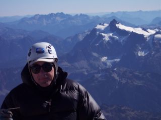
Little Tahoma Peak juts up behind me as I stand at Camp Muir. Little Tahoma is the third highest peak in Washington state - Mt Rainier is the highest.
 This is the massive rock that is directly behind me in the above picture. When I climb Mt Rainier, I will cross the glacier (in foreground) toward the right side of that rock, hike around and behind the rock, then climb to the left up to the summit (can't see summit from here - it is much to high).
We continued our descent. Along the way, as the sun continued to lower in the sky, the shadows shifted as did the landscape and I captured the images below as well.

By looking closely you may see a striated pattern of lines in the snow (mid-screen).
The well lit glacier at the top of this photo, ramping from right to left, had a shimmering, soft, mirror-like texture like none I have ever before seen.

 A view of Mount St Helens (background) and the Tatoosh Mountain Range (foreground).